Reaching for the peak: A hike up Mt Longonot

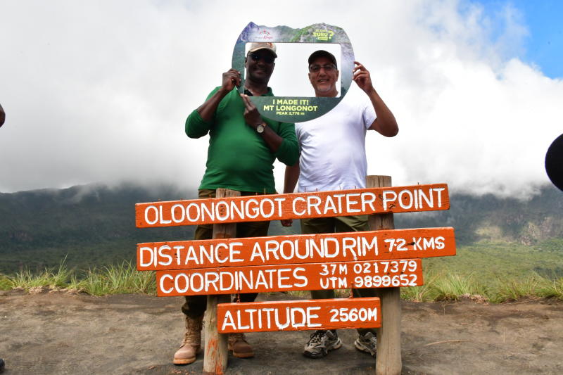
Tourism CS Najib Balala (white t-shirt) joins hikers on Mt Longonot. [Antony Gitonga, Standard] 

A road trip with friends can be a fun experience. And that is how the weekend started.

Aboard the car to Mt Longonot National Park from Nairobi, via Naivasha were a crew of tourism industry professionals and a film crew. I got to tag along for my first ever hike up a mountain.

I am one of the majority of Kenyans who have yet to take advantage of the gorgeous landscape that is our country, which sees hundreds of thousands of international tourists fly in yearly.

Statista, a marketing and consumer data company places the number of visitors Kenya received in 2021 at 870,500, with more than 300,000 picking Kenya as their holiday destination.

It is a crucial sector for our country and brings in the second-highest foreign-exchange revenue after Agriculture.

The Ministry of Tourism points out the country has made incredible strides in the tourism sector over the last few years.

“The country’s Tourism arrivals grew by 3.9 per cent from 2.02 million tourists in 2018 to 2.05 million tourists in 2019. Domestic tourism numbers in Kenya grew from 3,645,144 in 2017 to 3,974,243 in 2018, recording a 9.03 per cent growth,” the ministry said in a June 2020 report.

Our visit to the South East of Lake Naivasha, where the mountain is located, took us three hours across the Nairobi- Nakuru Highway. We made a stop about halfway through to find gas station washrooms and top up on our snacks and drinks.

We arrived in Naivasha Town around 10 pm after taking off around 6.30 pm and stayed at a peaceful, homely boutique hotel in the town. The air was humid and the weather felt freezing cold.

It helped that the reception was warm and the food even warmer - we ate several servings of ugali and fish for dinner, and after a quick team brief, everyone was eager to head to their room and rest up ahead of our hike up Mt Longonot the next day.

CS Balala takes a selfie with other hikers on Mt Longonot. [Antony Gitonga, Standard] 

If you are visiting the area, some tips are to carry warm clothing, jackets, socks and hats.

The Wilderness Society, an environmental conservation website, offers other pointers for similar daytime excursions.

They include checking the weather to avoid afternoon rainstorms, getting to the destination before dawn for better chances of spotting wildlife, exploring only the known trails and carrying the right shoes for hiking.

“Do not litter” is a big one, and proves to be a statement repeated and reiterated all through the adventure.

“A typical mistake hiking beginners make is wearing jeans and regular clothes, which will get heavy and chafe if they get sweaty or wet. Wear wicking workout clothes, which are designed for being active,” The Hiking Guy, a blog reports.

It adds: “Long pants or tights are good for making sure your legs do not get scraped up on bushes along the trail. Likewise, long sleeve shirts will protect you from the elements, but you can roll up the sleeves when it is hot.”

The website notes that good shoes are crucial for the experience, suggesting comfortable sneakers or trail runners.

CS Najib Balala hikes Mt Longonot. [Standard]

The hike

I had to be up by 6am on D-day. Our call-time had been set for 7am when we would take the 20-minute drive to Mt Longonot National Park.

One of the exciting parts of this trip is that it would include a special guest, the Tourism and Wildlife Cabinet Secretary, Najib Balala.

The CS was expected at the park early in the morning, and he would hike up the mountain together with several teams that had travelled to the town for the breathtaking experience.

After a quick, but moderately heavy breakfast, we were off to the park in the icy cold morning. It was warmer by the time we got there, and it was finally time.

Facing the mountain is a serene moment. There is the greenery all through, the majesty and the sheer challenge of it all.

The possibility of coming across wildlife was also pretty exciting. The park boasts the presence of buffaloes, elands, lions, leopards, bushbucks, zebras, giraffes and Grant gazelles.

The Kenya Wildlife Service (KWS) describes the Mt Longonot National Park as a “sheer adventure” on its website.

“Rising from the floor of the Great Rift Valley like a monolith is the extinct volcano of Mount Longonot. A unique feature is a thick forest that lies within the crater of the mountain. The crater rim also provides great scenic views across the beautiful Rift Valley all the way to Lake Naivasha.”

Soon, the CS and his team were on location. A tour guide told us all it was crucial to do some warm-up exercises before taking on the mountain.

The entrance of the park is lined with intriguing artwork, including the skulls of buffaloes that once roamed the area. It was promising of the pure nature we were about to experience.

“The park was established in 1983 under legal notice number 10 and this was purposed to protect and preserve Mt Longonot National Park or the crater for its local and international importance,” a KWS official, Muchiri, told the teams as we walked over to the starting point when the road begins to slowly steepen.

“It has been an attraction for many people. We are at an average of 50,000 visitations at the moment, 90 per cent of which is domestic tourism. It has all the potential to surpass that. One of the reasons is that the Standard Gauge Railway station is just 3km from here.”

Other than his team, the CS was accompanied by KWS Director General John Waweru.

The guide in charge of the hike advised hikers not to rush; instead, to take their time.

“We are not in a competition and we are not issuing certificates for those who reach the top,” he said, sending our entire group into laughter. Everyone seemed to be in great spirits.

A hike up Mt Longonot is estimated to take about four to five hours.

It was around 10am when we started, and the ascent was slow, steady and more challenging by the minute. We passed a spot called Buffalo Point, where the beasts like to gather and eat the freshest vegetation. But we did not get to see them - perhaps we would be lucky enough during our descent.

Everyone was eager to get to the halfway mark, and the guide had to keep encouraging us.

“Once we get to the 50 per cent, we shall have a brilliant view of Aberdares, Kijabe Hills, Mt Suswa and a little bit of Lake Naivasha. Of course, the view is best when we get to the rim,” the guide explained.

Speaking about his experience at the halfway mark, a tired, but pleased Balala said it had been worth it so far.

It is not an easy challenge, I will tell you that. It needs endurance, stamina, patience and courage,” the CS said.

He added humorously: “I was climbing up and asking myself, nani amekutuma ufanye hii kazi? (Who forced you to do this?)”

“We are always in the office doing office work, so activities like these are good for maintaining a healthy lifestyle.”

I will have to warn future Mt Longonot hikers about a flight of stairs right after midway through the mountain.

Those stairs don't seem to end, and they are constructed at one of the steepest points on the mountain - that had to be the hardest part of the hike. It is that point where you are too far to return, and too close to the top to give up.

As though to reward us for pushing through with the climb, we could spot wildlife in the views at that point. Nonchalantly posing under trees were a couple of giraffes. Feeding near them were zebras and Grant gazelles.

They seemed undisturbed by our presence in the distance, and although we were in awe, we had to blend into their home and not disturb their peace.

At around 2pm, I finally made it to the peak of the mountain. KWS points out how incredible the views at the top are, but it’s safe to say that the beauty of it cannot be put into words.

From the thick green forest in the crater to the heavy fog across the rim, then topping it off with panoramic views of the surrounding attraction sites, it is a moment when time seems to standstill.

The peak of Mt Longonot stands at 2,776M. It is a strato-volcano whose name is derived from the Maasai word Oloonong’ot, meaning “mountains of many spurs” or “steep ridges.”

After our descent, the CS addressed the possibility of revamping the park in order to attract more tourists.

Balala said that more products and experiences should be created in order to make the trip more enjoyable and diverse.

“If we maintain ourselves to just safari and taking pictures; that is not going to increase the numbers of tourists we want. And it is not just about tourists in general, but also our Kenyan, domestic tourists,” Balala said.

He added: “People go there and do camping - why can’t we have a zip-line from one side of the crater to the other?”

“It is a world-class experience and it will put Kenya on the global map. Whenever I travel to KWS parks, I see only opportunities and not problems,” the CS added.  

[email protected]