Premium

Mackinnon Road Town: Chase for revenues continues to fan war between Taita, Kwale

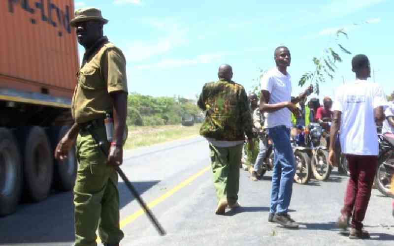
Police officers patrol the Mackinnon Road area that is at the centre of a boundary dispute between Taita Taveta and Kwale counties. [Courtesy]

It is as if the once battle-scarred Mackinnon is frozen in time if the rusticity of the area that served as a World War II combat outpost is anything to go by.

Not even the grating noise from vehicles on the busy Nairobi-Mombasa highway that cuts the town in the middle seems to rouse it from its seemingly long slumber.

Mackinnon town could also be said to be at peace with an unhurried pace of life. Not even the vicious wars over its location between Taita Taveta and Kwale counties appear to disturb it.

However, the area's role in the 1939-1945 World War II is well documented because it is the place where the first British military airfield was located.

Historical accounts indicate the airfield opened in 1942 for the emergency landing of the British Royal Air Force fighter planes during the war. It was abandoned after the war.

The airfield lay on a plain of uninhabited bush. Today, very little has changed in the town surrounded by the barren wilderness of the Taru desert and the sprawling Tsavo National Park.

Mackinnon is yet again in the throes of another but different kind of war, this time pitting Taita Taveta and Kwale counties. Both devolved governments are claiming the town.

Political analysts claim that at the centre of the present war is revenue collection in the town whose economy is largely dependent on transit vehicles, lodges, eateries, and tourism.

Owing to its strategic location along the Northern corridor linking landlocked countries of the Great Lakes Region with the Kenyan seaport of Mombasa, the hospitality business is booming.

Taita Taveta Finance Executive Dawson Katuu says the town generates at least Sh60 million in revenue per year from business permits, land rates, and cess.

“It has the potential of generating more,” he says.

Mackinnon Road Town also boasts of a major landmark, a mosque that is an oasis of peace and spiritual nourishment for many religious adherents.

Mackinnon mosque, with its conspicuous minarets towering over the small town, is a sight to behold and is regarded as a shrine where many stop to commune with God.

Stories are told how trains and buses slowed down when nearing the mosque where the tomb of the revered Muslim saint, Seyyid Bhaghali, who died in the 19th century, is.

Thousands of pilgrims throng the mosque to pay homage to Baghali whose family tree they claim, traces back to Prophet Muhammad, the revered prophet of the Muslims.

Legend has it that Bhaghali, who was reportedly one of the Indian labourers in the construction of the Kenya-Uganda railway, had tremendous strength and mystic powers.

History by the late Ikram Hassan, a second-generation Kenyan Indian, indicates that Bhaghali arrived in Kenya in 1890. It says he died along with two of his colleagues when a trolley they were riding spiraled out of control.

But the story of Mackinnon Road cannot be complete without tracing the origin of its colonial name. The town is named after a Scottish businessman, the late William Mackinnon.

Taita elder Madevu Mwangura says Sir Mackinnon established the Imperial British East Africa Company (IBEAC), which built the Mackinnon oxcart road from Mombasa in 1890.

Taita Taveta has sites with settlers' names like the Grogan Castle, named after Ewart Grogan, Maktau, a corruption of the military command mark time, and Voi town’s Kariokor, carrier corps, estate.

Mwangura, 75, says fleets of fighter squadrons flew from the Mackinnon and Ikanga airfields to support the eastern fleet during the World War.

“Mackinnon town is where fleet fighters’ squadrons flew ashore to support the eastern fleet  of the British East Africa protectorate during the War,” says Mwangura, also a tour guard in the town.

Colonial history also shows that the town was used for training roles and coordination of security operations, until it was disbanded on August 11, 1943.

“Bhaghali and Sir William Mackinnon history would be a major source of revenue from religious pilgrimage or battlefield tourism,” says Mwanaisha Kadenge, a woman rights activist in Taita Taveta.

Kadenga says Taita Taveta and Kwale counties see Mackinnon Road town’s Islam and WWII connection as an area they can exploit to attract tourism and pilgrimage in future.

Former administrators at the Coast like Boniface Mwatela, however, say Taita Taveta was not part of the Coast, until 1947. The former Kwale Division Officer says Taita Taveta was administered from Embu.

“The conflict between Kwale and Taita Taveta can easily be solved if politicians stop inciting locals. Elders from both the Taita and the Duruma people can easily solve it,” said Mwatela in a recent interview.

Taita Taveta leaders claim Mackinnon Road was previously in their jurisdiction until it was unilaterally transferred to Kwale in the late 1960s.

Taita Taveta governor Andrew Mwadime maintains the boundary between the two administrative units is at Landi Ya Mwembeni, but Kwale’s Fatuma Achani says it is at Miasenyi near Maungu Township.

According to colonial and post-independence maps seen by The Standard, the boundary between Kwale and Taita Taveta lies in Miasenyi near Maungu town.

But the Taita Taveta administration insists the boundary should pass in the middle of the Mackinnon Road trading centre, at Mbele Primary School, near the Mackinnon Road Kenya Wildlife Camp.

They blame the colonial administration for the boundary mess, saying before the border was altered, the defunct Taita Taveta county council collected revenue in Mackinnon town.

Former fiery Wundanyi legislator Mashengu wa Mwachofi says the boundary between Taita Taveta and Kwale districts was previously understood to be on Taru hill.

“The long-standing boundary dispute has led to violent confrontations and it is time to end this conflict and let the people live freely,” said Mwachofi.

The row escalated in 2018 after former Taita County Assembly Speaker Meshack Maghanga and four revenue officers were arrested by Kwale askaris for putting up a signpost to claim the town territory.

The five erected the signpost to mark the purported new boundary between the two counties at Landi Ya Mwembeni, past Mackinnon town, which Taitas claim to be the original boundary between the two counties.

The Standard has reliably learned that the conflict escalated after reports emerged that there were deposits of minerals, like coal, gold, and copper in the area.

The national government has designated the area as Block 119, encompassing Vigurungani and the Taru desert, for oil exploration, indicating the potential for oil deposits.

“It is all about mineral deposits in the area and revenue for counties. It has nothing to do with the locals,” says former Taita Taveta County Council chairman Christopher Nyange.

National Lands Commission chairperson Gresham Otachi has been meeting the warring parties in an attempt to address the boundary dispute.

The National Cohesion and Integration Commission has also tried to broker peace.