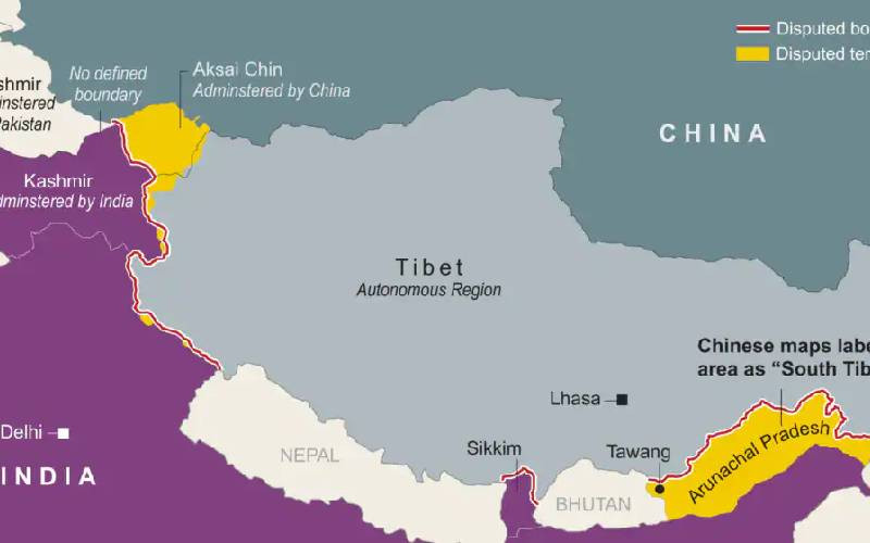
India protests Chinese map claiming disputed territories

JavaScript is disabled!

Please enable JavaScript to read this content.

Map shows border disputes between China and India. [Reuters]

India said on Tuesday that it had lodged a "strong protest" with China a day after Beijing released the 2023 edition of its standard map showing Aksai Chin - an area of Kashmir mostly controlled by China - and the northeastern Indian state of Arunachal Pradesh within Chinese territory.

The map was released Monday on the Chinese Ministry of Natural Resources standard map service website, just days after the two nations agreed to work to ease tensions at their disputed border.

The map also includes Taiwan and the South China Sea as Chinese territory.

On Tuesday evening, India's Ministry of External Affairs announced it had contacted its Chinese counterpart to object.

"We have today lodged a strong protest through diplomatic channels with the Chinese side on the so-called 2023 'standard map' of China that lays claim to India's territory," MEA spokesperson Arindam Bagchi said.

Just last week, Prime Minister Narendra Modi and Chinese leader Xi Jinping met at a BRICS summit in South Africa and agreed to "intensify efforts" to reduce tensions along the border. Both countries announced the agreement as a major step toward improved relations.

The release of the map also comes ahead of the multinational G20 or Group of 20 nations' summit, which is being hosted by India in New Delhi on Sept. 9 and 10 and is scheduled to be attended by Xi and other global leaders.

Manish Tewari, a member of parliament from the opposition Congress party, said Tuesday that the Modi government should seriously consider whether to host Xi at the summit.

Ill-defined border

Nuclear-armed India and China lay competing claims to vast swathes of territory along their ill-defined border - called the Line of Actual Control or LAC - which runs for more than 3,500 kilometers from Ladakh in the northwest to Arunachal Pradesh in the northeast.

The border, running through remote, rugged and snow-covered Himalayan ranges, was never clearly demarcated by India's former British colonial rulers. After independence in 1947, India and China failed to agree on a common frontier, and the border dispute has continued.

The dispute escalated into a full-fledged war in 1962 when, according to India, China occupied 38,000 square kilometers of Aksai Chin. India still claims the China-occupied region as part of its Ladakh territory while China insists that Aksai Chin was long part of the ancient Chinese empire.

China claims that India occupies some 90,000 square kilometers of its territory in India's northeast, including Arunachal Pradesh, which it views as southern Tibet. But New Delhi, which controls Arunachal Pradesh, insists it is part of India.

In April, China issued a statement declaring that it had "standardized" the names of 11 places in the region, also called "Zangnan" by China. India rejected the Chinese claim and MEA's Bagchi asserted: "Arunachal Pradesh is, has been, and will always be an integral part of India."

A Chinese Foreign Ministry spokesperson said in April at a regular news briefing in Beijing that the southern Tibet region was indeed a part of Chinese territory.

Dialogues fail to resolve dispute

Diplomatic ties between the two nations have remained frosty since their soldiers engaged in hand-to-hand combat in the Himalayan region of Ladakh in 2020. India reported 20 of its soldiers had been killed, and China later acknowledged the deaths of four Chinese soldiers.

Since then, the countries have held more than a dozen diplomatic and military-level dialogues trying to resolve the border dispute but with limited success.

On Tuesday, spokesperson Bagchi said that China's claims to Aksai Chin and Arunachal Pradesh have "no basis" and that steps like the release of the map "only complicate the resolution of the boundary question."

Indian External Affairs Minister S. Jaishankar told Indian television channel NDTV that claiming parts of Indian territory was an "old habit" of China.

"These [territories] are very much part of India. This government is very clear [about] what our territories are. Making absurd claims doesn't make others' territories yours," he said.

Congress leader Tewari said that China must end its occupation of Indian territory.

"Today, the real issue between India and China is that they have transgressed along the Line of Actual Control at multiple points on a theater level. Analysts believe that the Chinese are currently in occupation of 2,000 square kilometersof Indian territory. This is the territory that the [Indian] government needs to get vacated," Tewari said.

"Under those circumstances, the government should seriously introspect - though the G20 is a multinational forum - whether it would be in accordance with India's self-respect to be feting a person in Delhi, Xi Jinping, who is in illegal occupation of 2,000 square kilometers of Indian territory."