For the best experience, please enable JavaScript in your browser settings.
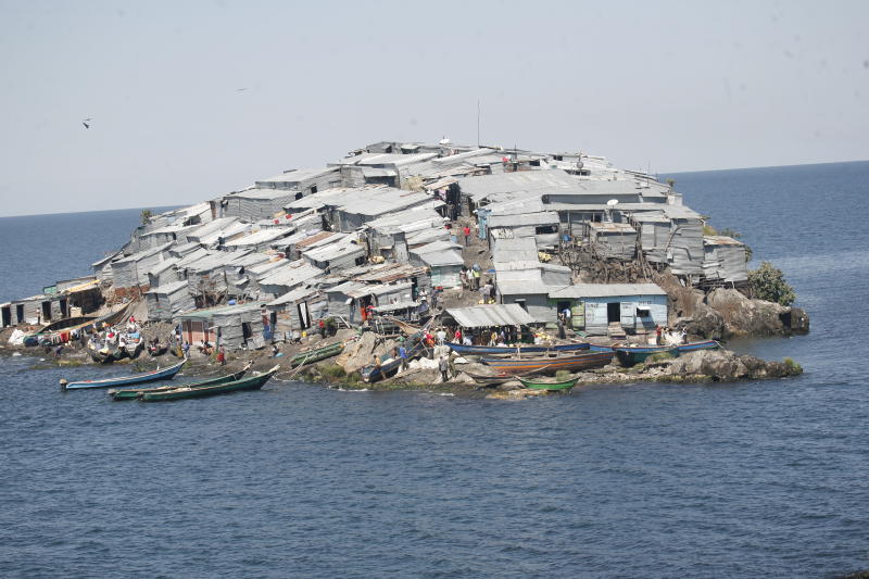
Kenya risks losing most of its islands in Lake Victoria to Uganda if a fresh survey of the boundary between the two countries is conducted.
The islands will be open to be claimed by Uganda if the two countries draw lines from Remba to Migingo islands and another one to Pyramid Island.
Foreign Affairs Cabinet Secretary Monica Juma announced a few weeks ago that the boundary demarcation that stalled in 2009 will start afresh in a bid to resolve the row over Migingo Island.
“It is a technical process to mark the boundary. Does it mean we are going to begin negotiating boundaries? No, that is not what it means.
“Our commitment is to respect the boundaries inherited at independence. That is an immutable staring point,” she said.
But former Lands minister James Orengo warns that this is a dangerous path that Kenya had rejected in 2009.
“If Kenya agrees, Uganda can slowly build its claim to extend its territory and fishing rights by taking all the islands. The dispute may be connected to resources in Lake Victoria,” he says.
Orengo says in 2009, Ugandan authorities wanted the lines drawn so that Migingo can be on their side but Kenya maintained that they use available maps deposited by the colonial governments and the military, with the support of coordinates from the 1926 Order in Council that showed the pyramid.
The maps show that Remba, Migingo and Pyramid islands are in Kenya but Orengo says the new line to be drawn will put them in Uganda.
During his recent visit to Kenya, Ugandan President Yoweri Museveni and President Uhuru Kenyatta agreed to put in place a commission that will review controversial border points.
Waste of resources
However, former Foreign Affairs Minister Moses Wetang’ula says Kenya should not spend any coin in a fresh survey, adding that the money should be used on “more important” areas like health and education.
“Any attempts to carry out a fresh demarcation is a waste of public resources because the survey of the front view of the Kenya-Uganda boundary was ordered by former President Mwai Kibaki and Museveni at a meeting in Nairobi and another one in Lusaka, Zambia,” he says.
Wetang’ula, who attended both meetings, says the two presidents committed to abide by the outcome of the survey, and that what Kibaki did is binding on his successor, President Kenyatta.
“There should not be any argument that Migingo is not in Kenya. We should agree with Uganda on what the survey report shows,” he says.
Stay informed. Subscribe to our newsletter
The dispute over Migingo started in 2004 when Ugandan authorities arrived on the island and hoisted their flag and forced Kenyan fishermen living on the island to purchase special permits from the neighbouring country’s government.
On March 4, 2009, the East African Legislative Assembly called for a peaceful resolution of the conflict. Kenya and Uganda then formed a team that spearheaded the demarcation exercise.
The Kenyan team comprised Wetang’ula, Orengo, then Internal Security Minister, the late Prof George Saitoti, Yusuf Haji (Defence) and the late Otieno Kajwang (Immigration). Ugandan Foreign Affairs minister Sam Kutesa led his delegation.
Orengo now says this survey is 95 per cent done, and there is no need to “water it down” with a fresh demarcation.
“We will waste more than Sh400 million that had been spent in doing the same job. The boundary will not change and it is important that the two countries sign and deposit with the African Union and the United Nations the 95 per cent of the area that is not in dispute before embarking on the remaining five per cent,” says the Siaya Senator.
The Kenya-Uganda border covers 580 miles of which 86 miles are in Lake Victoria.
Fishermen arrested, tortured
On the Migingo row in which several local fishermen have been arrested and tortured by the Ugandan authorities, Orengo says only two disputes had not been resolved and the preliminary report is still with the officials who were operating under the Office of the President.
Preliminary findings show that the 1.5-acre island is 510 metres inside Kenya.
Orengo says the fresh demarcation will not resolve the problem, but will graduate it from a boundary row to a territorial dispute.
“The only option is to go to the International Court of Justice (ICJ) that is created to solve such disputes,” he says.
He says the ICJ has solved several disputes between neighbouring countries peacefully for instance, the ownership dispute between Cameroon and Nigeria over oil rich Bakassi Peninsula, which was decided in 2002 in favour of Cameroon.